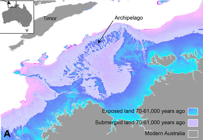
QUEENSLAND, AUSTRALIA—According to a Cosmos Magazine report, a new study of ocean floor topography has yielded a 3-D map of Sahul, an Ice Age landmass submerged off the northwest coast of Australia. Between about 70,000 and 61,000 years ago, Sahul consisted of an archipelago that stretched toward Indonesia and connected what are now northern Australia’s regions of the Kimberley and Arnhem Land, said Kasih Norman of Griffith University. As sea levels dropped during the last Ice Age, a land area slightly larger than Japan with a gigantic inland sea was exposed. Demographic models indicate that as many as 500,000 people may have lived in Sahul at this time. Then, as sea levels began to rise between 14,000 and 9,000 years ago, Sahul was quickly submerged. “People that were living in this region would have seen the landscape going underwater, almost before their eyes,” Norman said. Archaeological data also records a rise in the number of stone tools in the Kimberley and Arnhem Land at this time. “That normally means that there’s a lot more people suddenly in that area,” he explained. Styles of rock art found in the Kimberley and Arnhem Land also changed during this period. “So there’s quite a bit of speculation out there [among] archaeologists and rock art experts that probably what we’re seeing is people bringing in those styles from off the shelf into these regions,” Norman concluded. Read the original scholarly article about this research in Quaternary Science Reviews. To read about Aboriginal sites that are now underwater within the Dampier Archipelago, go to "Around the World: Australia."
Ice Age Landmass Mapped Off Australia’s Northern Coast